
Geography of Zimbabwe
Map:
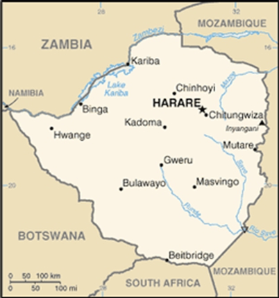
Location: Southern Africa, between South Africa and Zambia
Capital: Harare
Size: slightly larger than Montana
Population: 12,084,304 (July 2011 est.)
Terrain: mostly high plateau with higher central plateau (high veld); mountains in east
Climate: tropical; moderated by altitude; rainy season (November to March)
Flag:
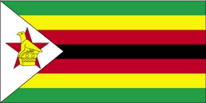
Flag symbolism:
seven equal horizontal bands of green, yellow, red, black, red, yellow, and green with a white isosceles triangle edged in black with its base on the hoist side; a yellow Zimbabwe bird representing the long history of the country is superimposed on a red five-pointed star in the center of the triangle, which symbolizes peace; green represents agriculture, yellow mineral wealth, red the blood shed to achieve independence, and black stands for the native people
National Anthem:
National Anthem – lyrics
Information retrieved from the CIA Factbook at https://www.cia.gov/library/publications/the-world-factbook/geos/zi.html
Lesson Plan Ideas for Geography of Zimbabwe:
- Check it out on Google Earth!
- Distribute copies of the map of Africa. Have students locate, label, and color the country of Zimbabwe. Have them mark the capital with a star and label it.
- Students can create a brochure of Zimbabwe, which should include information such as location, population, terrain, climate, size, flag, etc.
- Students can listen to the National Anthem
- http://www.youtube.com/watch?v=x6QjMCIyASM&feature=related (music only as flag is shown)
- Students can listen to “Our Zimbabwe” which is a beautiful song – found both in Shona and English with a slideshow.
- http://www.youtube.com/watch?v=C3Up8tx832k (Sung in Shona with slideshow of Zimbabwe)
- http://www.youtube.com/watch?v=oXY6nsDP4i0 (Sung in English with slideshow of Zimbabwe)
- Have students create a poster that includes the flag of Zimbabwe as well as what the symbols and colors mean.
- Check out more information online
- http://www.ducksters.com/geography/africa.php (Africa geography – click on country and get map, flag, population, and much more!)