
Geography of Kenya
Map:
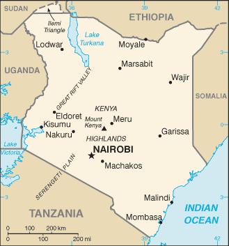
Location: Eastern Africa, bordering the Indian Ocean, between Somalia and Tanzania
Capital: Nairobi
Size: slightly more than twice the size of Nevada
Population: 41,070,934 (July 2011 est.)
Terrain: low plains rise to central highlands bisected by Great Rift Valley; fertile plateau in west
Climate: varies from tropical along coast to arid in interior
Flag:
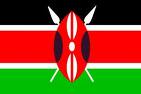
Flag symbolism: three equal horizontal bands of black (top), red, and green; the red band is edged in white; a large Maasai warrior’s shield covering crossed spears is superimposed at the center; black symbolizes the majority population, red the blood shed in the struggle for freedom, green stands for natural wealth, and white for peace; the shield and crossed spears symbolize the defense of freedom
National Anthem:
National Anthem – lyrics in English and Swahili
Lesson Plan Ideas for Geography of Kenya:
- Check it out on Google Earth!
- Distribute copies of the map of Africa. Have students locate, label, and color the country of Kenya. Have them mark the capital with a star and label it.
- Students can create a brochure of Kenya, which should include information such as location, population, terrain, climate, size, flag, etc.
- Students can listen to the National Anthem
- http://www.youtube.com/watch?v=3fDXD5_XCtw (Kenyan child singing the first verse in English and then Swahili)
- http://www.youtube.com/watch?v=lIljogSlZwc (Kenyan National Anthem music with picture slideshow of Kenya)
- Have students create a poster that includes the flag of Kenya as well as what the symbols and colors mean.
- Check out more information online
- http://www.ducksters.com/geography/africa.php (Africa geography – click on country and get map, flag, population, and much more!)