
Geography of Democratic Republic of Congo
Map:
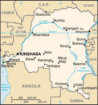
Location: Central Africa (straddles the equator; has narrow strip of land that controls the lower Congo River and is the only outlet to South Atlantic Ocean; dense tropical rain forest in central river basin and eastern highlands)
Capital: Kinshasa
Size: Area is slightly less than ¼ of the size of the US
Population: 71,712,867 (July 2011 est. from CIA factbook)
Terrain: vast central basin is low-lying plateau, mountains in the east
Climate: tropical, hot and humid in equatorial river basin, cooler and drier in southern highlands. N of Equator wet season (April – – October)…dry season (December –February). S of Equator wet season (November-March)…dry season (April—October).
Flag:
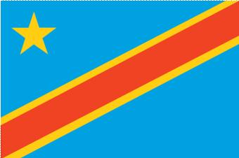
Flag symbolism: sky blue field divided diagonally from the lower hoist corner to upper fly corner by a red stripe bordered by two narrow yellow stripes; a yellow, five-pointed star appears in the upper hoist corner; blue represents peace and hope, red the blood of the country’s martyrs, and yellow the country’s wealth and prosperity; the star symbolizes unity and the brilliant future for the country.
National Anthem (Arise Congolese)
Information retrieved from the CIA Factbook Website
Lesson Plan Ideas for Geography of DRC
- Check it out on Google Earth!
- Distribute copies of the map of Africa. Have students locate, label, and color the country of Democratic Republic of Congo (explain that older maps/globes have Zaire). Have them mark the capital with a star and label it.
- Students can create a brochure of DRC, which should include information such as location, population, terrain, climate, size, flag, etc.
- Students can read the words to the DRC National Anthem and then listen to it sung.
- http://www.youtube.com/watch?v=aWh8IbMXZqY (National Anthem sung in French with flag in background)
- Have students create a poster that includes the flag of DRC as well as what the symbols and colors mean.
- Check out more information online
- http://www.ducksters.com/geography/africa.php (Africa geography – click on country and get map, flag, population, and much more!)
- https://www.cia.gov/library/publications/the-world-factbook/geos/cg.html (CIA World Factbook info about DRC)